Area: central Nepal (Himalayas), Annapurna and Manaslu ranges.
Dates: best XC from end of january to end of march.
I've been flying 15 years, enjoying anything related to paragliding: soaring a 100 meter slope, finishing some beautiful triangles in big mountains, parawaiting hours and hours with friends... but never discovered the bivy flying till I went to live in Nepal. It's not that I didn't know about it or not even tried it: I remember in 2000 putting a sleeping bag and some food inside my harness, flying alone into the mountains but finally always gliding back home.
In Nepal I met pilots looking forward to discover the bivy flying too . The weather conditions during the winter time are very predictable and the valley breezes not too strong in this central area. The rice fields and villages in high altitudes helps to find top-landings / take-offs but is also a resource of food, water and even beds.
So all the ingredients were ideal for me to finally discover the bivy flying! The next journal is a very reliable ans short bivy flight, for me the 3rd time I did it, the perfect one to discover this amazing new way to paraglide.
----- DAY 0 -----
Location: Pokhara and Sirkot
Date: 09/02/14
Group: 6 pilots
I found out there is often a "day 0" on bivy flying: preparing the equipment, checking batteries, spot, radios, food, maps... and to do the approach to the start point of the adventure. At our day 0 we took a 4 hours jeep ride from Pokhara to Babu's base camp (babuadventure.com) in Sirkot, towards South. We stayed the night there to be fresh, clean and fed before we started the next morning. Babu is an inspirational local pilot who participated in the X-Alps and flew down the Everest on a tandem, National Geographic Adventurer of the 2013. His place, just a few minuts of a take-off, it's perfect to stay there for few days and discover the local XC routes.

pic: Babu and his smile. pic: A local kid from Sirkot.
----- DAY 1 -----
Take-off: Sirkot (1.750m)
Landing: Pokhara (800m)
XC Distance: 37km
Date: 10/02/14
Every time I've been in Sirkot I woke up early to see the sunrise. Worth it! The views of Annapurna, Daulaghiri and Manaslu are unique! On stable days Sirkot starts to work late, by 12 or 1pm, so expect a short flying day (by february is dark by 6pm I think).


pic: the take-off and small town of Sirkot. pic: beggining of the flight.
 The flight consist in crossing various small valleys, so you need to get max. altitude at every ridge before the cross. The first 25km aprox. of this flight have big possible landings and South wind valley system, while as close you get to Pokhara, the wind valley changes to East and the landings are smaller.
You’ll never fly too far from the main road, so if you land somewhere at the bottom of the valley you can catch a bus to Pokhara (it will cost you no more than 3$).
We finally flew 2 hours and landed in Pokhara. 1 of the 6 pilots landed somewhere in the middle of the flight, so we didn't go too ahead from him so he would catch us the next day. Pokhara and its facilities were a very tempting place to spend the night. So we spent the night there waiting for our lost friend. It wasn’t a very adventurous bivy flight night: sleeping in comfortable beds, eating pizza and drinking a beer, but hey, there is no rules in bivy flying :)
----- DAY 2 -----
Take-off: Sarangkot (1.450m)
Landing: Pokhara (800m)
XC Distance: 0km
Date: 11/02/14
The day looks too unstable, the clouds on the back are growing fast and we go up to the take-off really late. Once there we can see there is no possiblities to follow our line towards East (getting deeper in bigger mountains) as it's too dark.
Flying in group is not easy. Every pilot has different skills, different levels of stress and multiple decisions that can change every minute. When conditions are easy and clear, mostly the whole group's mind is easy and clear. Not for that day where conditions were getting bad pretty fast. 4 of our friends decided to climb one thermal in Sarangkot and glide towards the big mountains. They toplanded some 4km from the take-off and placed themselves in a good position for the next day's route.
Because my friends were pretty close I decided to glide back to Pokhara and joint them in the air the next day. My friend Mathieu decided to come with me so the next day I didn't need to fly alone the first part of the flight. And that was for me a good lesson to learn, fly always with somebody else in bivy flying, specially if you go into remote areas (even if you have a spot tracker).
The next day we couldn't catch our group, and then we overpassed them somewhere and we never flew together again on that trip. Fortunately Mathieu that 2nd day landed with me and I could keep flying with a friend and not alone, making this adventure more fun and safer.
 |
| in 2013 I did more or less the same route. Here with Mitch Riley and some happy kids. |
----- DAY 3 -----
Take-off: Sarangkot (1.450m)
Landing: Baglung Pani (1600m)
XC Distance: 48km
Date: 12/02/14
 Our friends can take-off earlier and start the cross towards East. Me and Mathieu are stuck in Sarangkot with a thousand tandem paragliders and weak thermals. After an hour in the air we finally manage to climb enough to cross the north valley that separates Pokhara of the big footrange of the Annapurnas. We glided towards the famous "Green Wall" and then flew fast East to catch the first group. We are flying with walkie-talkies and not proper 2m radios (mistake) and the coverage and battery consume of these ones is bad, really bad. So we lost communication with our friends. We didn't see them and it looks they landed somewhere a bit out of the route. We decided to topland before a big valley crossing; it's getting late and we dont want to be too far from our friends.
We toplanded in Galegahun, a beautiful spot in the mountains I landed a year ago. That time we had problems with the ACAP (Annapurna Conservation Area) officer, telling us we couldn't land or take-off in this area if we didn't have the Trekking Permit . In the map it looked clear we didn't cross the line of the Park but the officer, an angry man, decided that yes.
I don't know what I was thinking this time when I landed there again... even if we landed a bit lower in a hided and pretty small area (smaller than an helipad). The same angry man came, with the same angry face and argument, asking us to pay him 4.000npr (some 40$) per person because we didn't have the trekking permit. After some light discussions and a couple of phone calls to some local friends, we managed to be able to take-off again and finally landed 400m lower.
So don't land in there even if it looks pretty! Probably you can land higher up (not close to a town) or then in Baglungpani, a lower place a 100% out of the ACAP.
The landing in Baglung Pani is the football field behind the school. A bit on the back of the ridge, but quite laminar the 3 times I landed there. From there you can walk 25 min to the main town "kapur Gahun" where you can find a local restaurant, beds and water.
 |
| our comfy beds. |
----- DAY 4 -----
Take-off: Kapur Gahun(1.600m)
Landing: Besisahar valley (600m)
XC Distance: 43km (one way and back)
Date: 13/02/14
We could talk the night before with our friends, they are in a bad place to take-off early. We are in front now and in a good enough spot to start earlier than them. After an hour walking without the gliders we find a rice field below the town that looks launchable. We wait there till there is enough breeze to have an easy take-off.

An hour later, by midday we are still soaring the bowl, not getting high enough to cross the next Besisahar wide valley. Thermals are weak, is getting more windy and there is no signs of getting better. This bowl is a small trap, a cul de sac.
Finally, with just few meters above the east ridge we "jump" in to the big valley hoping the lee side works. And finally, very low, we get the lee thermals, strong and vertical, with some enoyed hawks that they don't like to share the mother-nature's energy.
 We manage to cross the valley, back in to south-west ridges, and maybe because is too early, maybe it's too low... but it's getting hard to climb up. We fly close to the jungle, checking the trees moving, the tibetan flags getting disturbed of their morning peace by the first strong thermals, and then we manage to catch the always glorious cloudbase. We play with the clouds a little bit, getting as high as possible, checking the new ridges towards east, imaginating the next magic line we are going to follow. And we glide, hands free, breathing deep and recovering some energy.
We are gliding into more isolated and higher mountains. The heart rate and the concentration increases when you get into new terrain, when is the first the time you see new mountains, new shapes, and your brain starts to create a virtual 3d air map: that's a venturi, that might be a good thermal trigger, that can be bad place to be... and there you have a landing in case your 3d map is wrong.
While we are concentrated getting high again, not so far away some high clouds are "eating" some of our precious blue sky. We don't care too much, we are finally flying high and fast. But just some minutes later we check again, those clouds are coming fast and starting to shade all that big terrain. The little cumulus start to disappear, our hopes to keep flying too.
I had some internet coverage the day before and I checked the weather forecast. It was showing rain for the next days. It wasn't overdevelopment but a proper front, rare in this time of the year. I kind of forget, thinking the weather reports here are not worlwide famous for being very precise. But now I had the very real prove: high and infinit clouds, west meteo wind... and suddenly I had this image of me parawaiting in the wet mountains for a few days and I didn't feel so adventurous anymore. I love bad weather, I love being "lost" in the mountains, but there are days that not, and that was the day.
So I contact my friend Mathieu, flying quite close to each other, I tell him my opinion (and my feeling of being in a nice and warm place the next days) and he finally agrees to come with me. It was a hard decision, we where having a lot of fun and we were still far from our goal, Kathmandu.
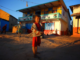
We flew back few kilometers to reach the Besisahar valley again. We landed in a footbal field, plenty of people came to see us, we look like astronauts coming from the moon: GPS, dressed with layers and layers of clothes, helmets, camera, vario bipping, and this strange flying carpet with so many thin lines.
The kids ask us where we come from, what's our name, and before we answered they were already asking for chocolate. The adults touched the material, the lines, they didn't believe it's hard enough.
Packed, we walked to the main road, and a couple of bumpy buses later (and few hours) we were back to Pokhara, our base camp. The rest of the team stayed in the mountains two more days but they couldn't fly, the weather report for once was true.
| a perfect glide on 2013. 4000m. |
Ivan Ripoll


0 comments:
Post a Comment